Category Archives: Travel

US west coast Part II

6 September 2017 – 8 September 2017: Las Vegas
Road Trip Map

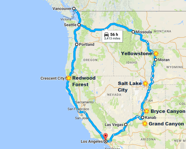
Back to LAX. Swap a small car with a medium SUV.

Then we drove to Las Vegas, a city that’s arguably more beautiful at night than during the day.

Revisiting the city, I have found out that that many free shows at various hotels, such as the Pirate Battle at Treasure Island, the Volcano at Mirage & Bellagio fountains were still on.

8 September 2017 – 10 September 2017: Grand Canyon National Park

We departed Nevada on the 8th Morning and headed towards the Grand Canyon.

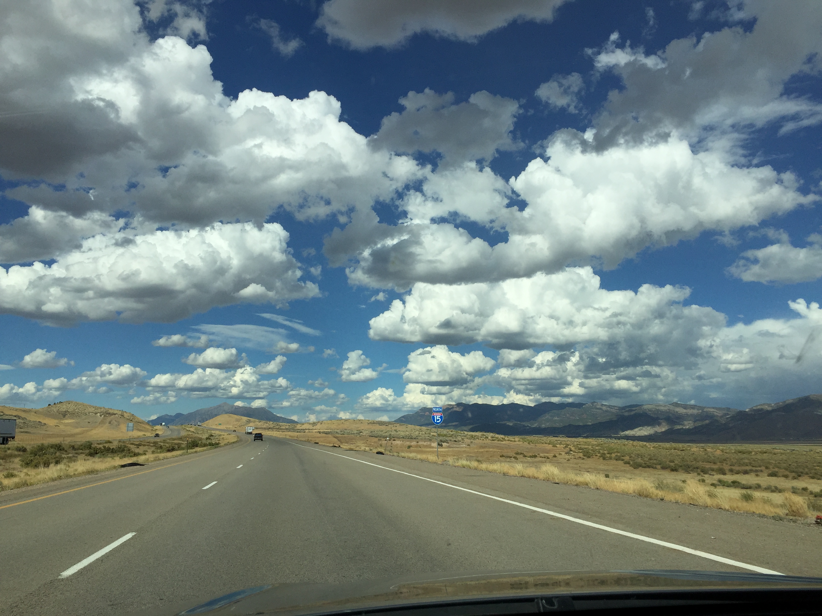
US roads are great for road trips – relatively flat and straight. Few cops hiding in the bushes like a lone lion trying to ambush a herd of migrating antelopes. Not many tolls to extract that extra few dollars from your wallet.

Grand Canyon is in Arizona, close to the border to Utah. We stayed in a small town called Kanab in Utah, which is at the border of Utah and Arizona. Although the longitude of Arizona and Utah are roughly the same, but because Utah has day light savings and Arizona does not, there is an hour time differences between the two.

The road went from Utah and Arizona back to Utah a few times, telling the exact time became hard if you were not watching where you crossed the border.

Utah and surrounding has some unique landscape and rock formations.

Horseshoe bend is named after its shape. The river beneath is the Colorado river.

There is a dam with a hydraulic power station a short drive away from the Horse shoe bend.

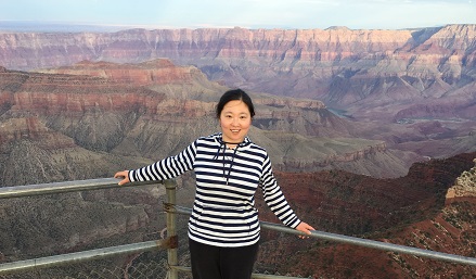
We went to the Grand Canyon North Rim the next day, it was cloudy in the morning, top of the canyon was shrouded in fog. But as the day went on, the fog started to disperse. By middle afternoon, the mist was gone. Grand Canyon took off the veil and revealed its true self to us. Sunset is beautiful in the canyon – sunlight shone from an angle and brought the contrast out of different layers. The scenery was spectacular.

Grand Canyon North Rim

Then the next day we proceeded to the South Rim.

If you are driving, there is no short cut between south rim and north rim. Going from North to South (or vise versa) involves driving around and cross a bridge over the Colorado River. The river isn’t the only thing named after the neighbour state to Arizona, there is also a place called Colorado City along highway 389.

Scenery at side of the road was also amazing, it’s not often when you see a gigantic gap in the middle of a vast flat plain.

South rim gives a more complete picture of the canyon than the North rim. Not only can you see the Colorado river beneath, different layers of the canyon are also very clear.

If you want to gain a bit knowledge on the grand canyon, the Yavapai Geology Museum is a place you should not miss. It’s also a place to understand why it’s called the grand canyon – there are three layers of canyon on top of each other, and the museum is one of the best places to witness this.

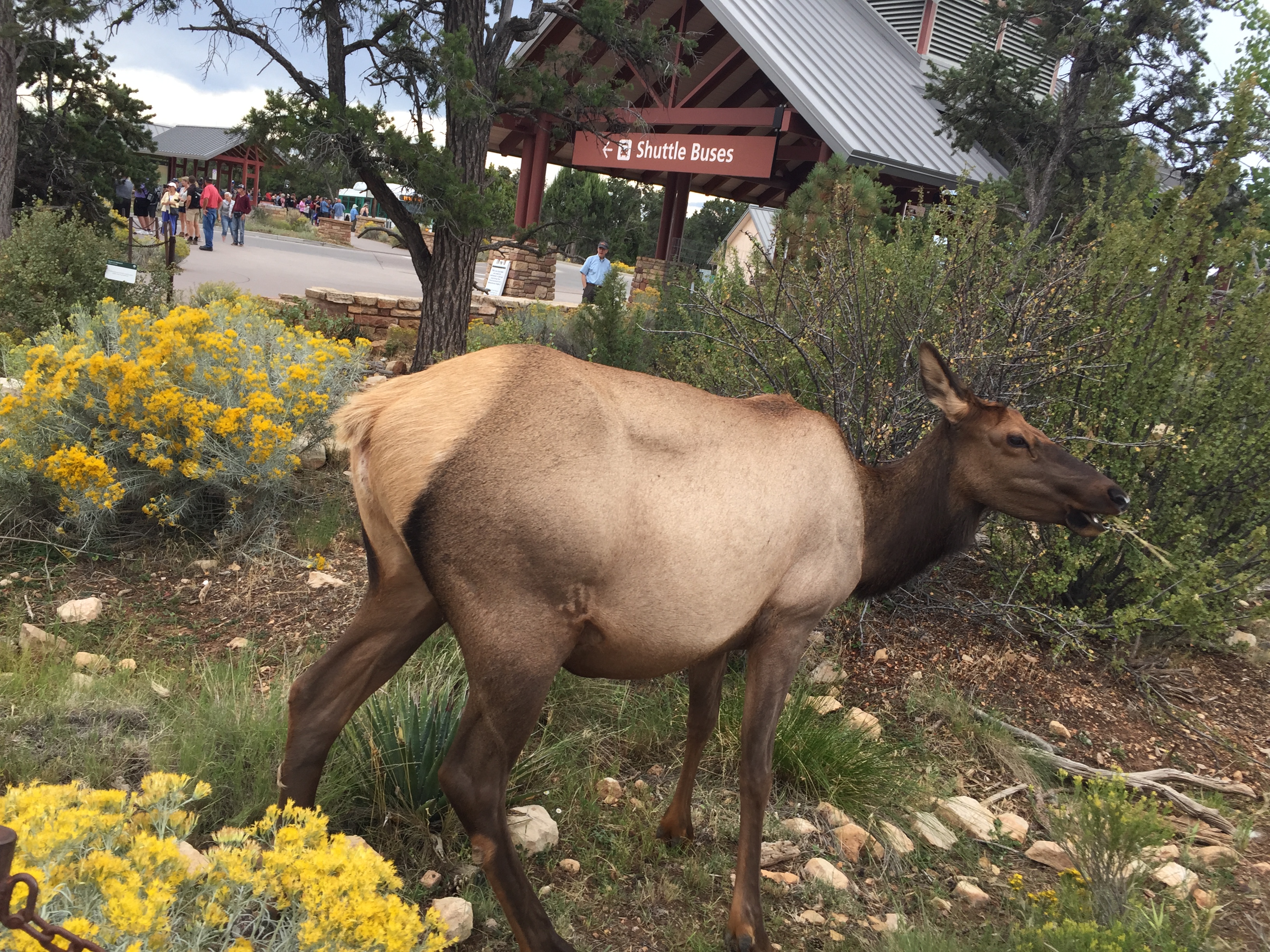
There were plenty of elks in the national park, they were not afraid of people either. On the way back from Grand Canyon south rim, we narrowly missed a deer that jumped right in front of the car.

Deer
10 September 2017- 13 September 2017: St George – Bryce Canyon National Park

Utah is an interesting place. I was warned of lacking of proper alcoholic drinks in the supermarket. Yep, no wine or hard liquor sold here, only Low-alcoholic beverages available. There were also some Mormons dressed in traditional clothing.

We visited Bryce Canyon national park. The view was special in its own way. It’s not often one sees a view point hoarded by a bunch of photographers. But at Bruce Point, we witnessed a group people with professional equipment positioning themselves at best viewing spots waiting for sunset.

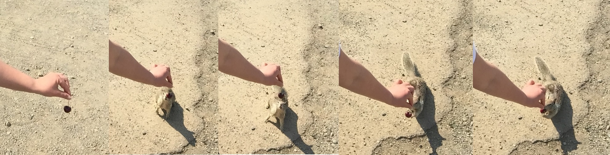
Various birds came to greet us at breakfast.

Birds in the Bryce Canyon National Park
13 September – 14 September:  Salt lake city

Keep on driving north, we stopped over at the Salt Lake City.

Road to the Salt Lake City

Since the city has been named after it, we became intrigued by this great salt lake. So we went to see the lake for ourselves. Then we found out there was place with plenty of wildlife – Antelope Island.

Going over to Antelope Island State Park involves driving across a bridge over the salt lake.

There were plenty of birds on the lake. According to an official website, the region supports several million birds during busy seasons of the year.

A part of the lake looked like a mirror, reflected sky.

Me at Grand Canyob

US west coast – Part 1

28 August 2017- 6 September 2017

This was the 3rd time I visited US.

The first time, it was with Singapore Airlines, flying from Sydney to Los Angeles. The flight went pass near the edge of north pole. The second time I flew to New York with Thai airways, stopping at Bangkok. This time it’s from Sydney to LA again, but it was with Fiji airways, stopped over at Nadi.

The night is short when you fly into an incoming sun. I still remember the first time when I flew to the other side of earth, the sun rose up twice as faster than usual, land mass and the dry salt lake drenched in morning light. In contrast to this time, which was mostly ocean view with a glimpse of Los Angeles where the plane landed.

I did a return road trip from Los Angeles to San Francisco and travelled this leg on my own.

Los Angeles

After resting for two days, trying to get over the jet lag. I Started driving along the coast from Santa Maria to Salina, stopping over at Carrizo Plain National Monument, partly because it’s on the way and partly because apparently the place had beautiful valleys full of flowers.

Except, I went there in the wrong season and all I saw where hays, beautiful golden hays. Despite inviting golden undulation, hiking was out of question because the temperature was soaring over 32 degrees (90 fahrenheit).

Carrizo Plain National Monument

There were surprising large amount of oil drills in California, both inland and near the coast.

Oil Drills
Wild turkey

Quite a few attractions along the coastal California are next to de-commissioned industry areas. Take Morro Bay for example, there is a huge piece of amazing rock in the ocean, plenty wildlife in the neighbourhood. But not far away there are also three gigantic chimneys.

Morro Rock

There were quite a few vista points between San Simone and Big Sur. At certain vista points, squirrels and other seabirds were awaiting in the car parks. Those animals seemed to be used to be fed by tourists – you can tell by the way those animals act towards humans. When wildlife looking at people with expecting eyes and itching towards any open car doors, there is a good chance that they had previous experiences of getting generous handouts from visitors.

Squirrel

At seal vista point, one can see plenty of elephant seals, lying lazily on the beach. Those animals are here all year round.

Elephant seals

Keep on driving up north, you will reach Pfeiffer Big Sur State Park. I didn’t get to drive through Big Sur state park because part of highway 1 was closed. So I spent one day doing the coast drive and another in the Big Sur state park. In between I spent two days away from the coastal area.

When I was in California this time, there was a heatwave, and being in the ‘warm season’ – It’s almost 40 degrees (103 F) inland. I stayed in accommodation more than I would like to. It’s so warm that San Luis reservoir seems steamy. Even visiting the park at 7am, the place was shrouded in red.

San Luis Reservoir

Back to coastal, McWay Falls in the Julia Pfeiffer Burns state park is a short walk from highway 1. Twenty minutes walk will take you to a place with spectacular views.

BigSur

Moss Landing is another example of wildlife sanctuary next to industrial area. Various websites indicated that monetary was a good place to spot sea otters.

So I went to there. But instead, I was greeted by a large colony of seabirds and seals. Sea otters on the other hand were hard to find.

Moss Landing

Eventually I ended up in San Francisco. Having a few apps of my own, the valley was a place I must visit.

me


Tarkine Coast Walk

I landed at Launceston on 10th March, then the rest of the people from our bushwalking group and I have been picked up from Launceston airport the next day & driven to the ‘edge of the world’. It was a 3.5 hour drive.  The walk started from Arthur River, it was much along the ocean with bits & pieces inland.

Tarkine Coast Walk Map

11 March 2017

The journey started from the end of the world, this end of the world:

End of the world

This section of the track was shared by 4WD, hikers, dogs, wallabies and from the footprints, horses.

There was a section at the beginning of the track where logs apparently swept up by the sea blocked part of the beach.

We camped next to a stream on the first night. The organizer of the trip was experienced and had planned the trip in such a way that we were camping near water sources most of the nights. Not only we were able to re-fill our water, there was also opportunity to take a quick dip.

Apparently there were also Aboriginal carvings near our campsite on the first night.

Tarkine Day 1

12 March 2017

We woke up in the rain, the weather was gloomy all the way until lunch. It’s the day we spotted the first sick penguin and we called WIRES from my phone, but there was nothing much else we could do.

There were a few smaller towns along the way and some houses had solar panels, I even spotted one with both solar panels and windmill. Nearly all of them had rain water tanks. I guess the drawback of living in such a beautiful place close to nature is the lacking of utility such as electricity and water so one has to live off the grid.

Lunch was at a scenic little lagoon. A few people dipped into water for a quick swim while I was busy drying the tent.

We came across a few beaches filled with seaweed. It smelt awful. I was uncertain whether it was from the rotting seaweed or the rotten seafood, I mean sea creature wrapped in those seaweed. Seagulls seemed to not mind the smell and happy to be next to it though.

Tarkine Day 2

13 March 2017

The first three days, we had to share the beach with 4 wheel drives and buggies. When automobiles go pass you every 30 minutes, it doesn’t feel too much like a wildness track. On the good side, we have been getting water from the friendly local drivers.

The weather has improved since the second day. By the third day, there was amazing blue sky. It’s marvellous to walk on the beach where there was endless ocean on one side, and perpetual sand dunes on the other.

We saw the second sick penguin on our journey, but this one was in much better condition than the last one. It turned itself around and prepared to go back to the sea.

Tarkine Day 3

14 March 2017

It’s the first day into the territory where no vehicles were allowed. We bush bashed a bit and was slight lost in the morning. But soon we found our orientation, and ended on the beach. It’s not terribly hard since it’s a coast walk, we aimed for the beach, any beach really. Then we headed south as usual.

By the afternoon, we ended on the endless beach again. Because the landscape was fairly exposed, the wind showed its power. There were forceful waves on our right side, we had to be careful dodging some persistent invading ones, and we could see sand has been blown off the sand dunes on our left.

Occasionally tide caught up with one of us and one ended up with wet boots.

Tarkine Day 4

15 March 2017

This morning, we walked into an area full of bush food. There were a few people in the group who were experienced in bushcrafts. So I had some fresh bush fruit. It was great experience.

We pitched our tent next to an open area next to the cliff. The wind picked up at night, I laid in my tent, worried about when my tent was going to give in and collapse on me. I even got out trying to tie down the line, but it did work – the gale was too strong. The around 4am, the wind changed direction and with it, brought the rain. This somewhat relieved pressure on my tent, so I was able to get some sleep finally.

Tarkine Day 5

16 March 2017

After a night of strong wind, I woke up in a half collapsed tent and only had 2-3 hours of sleep.

Because it rained during the previous night and in early morning, we had to go across a few swamp.

I jokely called the water we have been drink the pure ‘Tasmania tea’ because of slightly yellowish stain in the water. But it’s very safe to drink, because the water was mainly from creeks and there were very few farms and towns up the stream. Colour of the water was from leaves.

The journey ended on the bank of Pieman River. We took a ferry down to Corinna, and were picked up by a shuttle bus after lunch.

Tarkine Day 6

17 March -18 March 2017

Back in Launceston, rested a bit, food was good.

Launceston
me

Wuhan/武汉

I have finally sorted out the pictures I have taken while on the rest of trip last month.

Most of them were taken in Wuhan(武汉). But there were a few taken in other cities and towns. A lot of those pictures were of tall residential buildings. They sprouted out mostly in the past 5-10 years. Before year 2000, there were almost none of those super tall towers, then bam! Now the city is now full of them.

There were also a few pictures taken around East Lake(东湖), Guiyuan Temple(归元寺), near the Yangtze river(长江) and at a few other odd places.

East Lake/东湖:

Guiyuan Temple(归元寺), HanZheng Jie(汉正街) & ZhongShan Park

Some other places:

If you love shopping, you should definitely visit HanZheng Jie(汉正街), large variety of goods are guaranteed at low prices! Although be able to speak Wuhan dialect does improve your bargain power in general.

Me
Me

Chengdu–Huanglong–jiuzhaigou / 成都-黄龙-九寨沟

20th September 2016 – 26th September 2016

Recently, my cousin and I visited Chengdu(成都), Huanglong(黄龙) and  Jiuzhaigou(九寨沟).

My Cousin
My Cousin

Chengdu is a is the provincial capital of Sichuan province in Southwest China, that houses some 14 million inhabitants. Most parts of the city are modern, but there are also a few ancient places reserved for their historical significance.

Sichuan is famed for its hot and spicy food. I like hot and spicy food, so when we first went to a restaurant and ordered dishes and waitress asked ‘normal hotness?’ I replied with ‘yes’. But my cousin reminded me ‘you are in Sichuan’. And she was right. Despite the fact that we ordered ‘slightly spicy’ food, it was much hotter and spicier than I had expected.

The route to Huanglong(黄龙) &  Jiuzhaigou(九寨沟) was through many tunnels.  The road followed Min river(). I was amazed to see many power transmission towers on tall mountains.

Huanglong is 3000 meters above sea level. So we were warned of altitude sickness. It wasn’t too bad for me, but there were a couple of people started throwing up while coach was traveling through the mountain region.

Huanglong was beautiful. We took the cable car up and walked down a couple of kilometres back to the entrance. I was constantly out of breath, most likely due to high altitude.

‘Jiuzhaigou(九寨沟) has a population density of 2000 people per square meter’, someone who has recently been there joked.  Although it’s a bit exaggeration, there were a lot of tourists.

We spent a whole day there, walking some 20+ kilometres up and down the ‘Y’ shaped valleys. There were buses running up and down the same route, and we caught those a couple of times too.

Jiuzhaigou’s famed for its beautiful waters. The water displayed alluring colours because of the mineral and algae in the water.

This is ophiocordyceps sinensis, also know as insect plant (冬虫夏草).

Cordyceps
Cordyceps

I bought some on the way back. Insect plant is formed when fungi invades worm,  and in China, it’s a herbal remedy. Apparently they only grow on tall mountains with altitude over 3000 meters.

On the road from Chengdu to Huanglong/Jiuzhaigou, we went past parts of the area worst affected by 2008 earthquake. Some of those towns were surrounded by tall mountains on all four sides with only one road going in and out of the place. Awe was how I felt.

Speaking of awesomeness, we have also had a day trip visiting Qingchengshan-Dujiangyan National Park (青城山-都江堰国家公园). Qingchengshan is famed for being one of the cradles for Tao religion and Dujiangyan is an irrigation system that was built some 2200 years ago. Dujiangyan divided river into two parts: inner river and outside river. The inner river is narrow but deep and the outer river is broad but shallow. Inner river is channelled into towns and farming area and the outer river is diverted away from civilization. During dry season, more water goes into the deep inner river while as during flooding, more water goes into broad outer river. Thus regardless of the weather, quantity of water into the town and farming area is regulated.

Warrumbungle

11 June 2016 – 13 June 2016

Have you ever look up at the sky thinking: there are billions of stars and planets and  humans have not been to any single one of them!

The fact is that the milk way alone is rumoured to have 100-400 billion stars with at least 100 billion planets. Still we humans have not visited any of them.

So last weekend I went to Warrumbungle for bushwalking and visit a private observatory with a bush walking group that I occasionally hang around with. And that was the question that bumped into my head while was preparing for the trip.

Bushwalking group - some new people and some old faces
Bushwalking group – some new people and some old faces

The trip went well, there were plenty of wildlife at Warrumbungle, beautiful scenery too.

Wallabies in front of headlights
Cute, fluffy apostle birds

Looking forward to the day when humans permanently land on Mars and give a definite answer to that old, profound question: ‘is there intelligent life on other planets’ and answer: ‘yep, we put them there.’

Me @ Warrumbungle
Me @ Warrumbungle

Uluru – Kings Canyon

22 May 2016 – 25 May 2016

Ayers Rock/Uluru
Ayers Rock/Uluru

The trip to Uluru started terrifically – even on the day before, with a roughly magnitude 6 earthquake close to the Ayers rock.

Things didn’t become better – first there was a water leak on the outbound plane. We sat near the very back and when we reached our destination, the rear door at back failed to open. So after waited for ages at the back of a long queue, we finally picked up the rental car and when we reached the campground, the cabin we had been given could not be locked. Later, the resort changed us to another cabin.

Cabin at camping ground

But that didn’t stop us driving to uluru-kata tjuta national park later that afternoon. After a short tour around the park, we waited for the sunset at designated area. There was no awe-inspiring experience induced by the colour changing rock because it was cloudy!

The next day when we waited for sunrise, it was even worse – it started drizzling. Did I read somewhere that it only rains several days out of a year in the area? This site even says that you would have to be lucky to actually be there when it rains. I guess I must be really lucky as always.

Hard being a plant in the desert

The trip went well despite all the small glitches.

The amazing scenery started as early as in the middle of the flight, the landscape in the centre Australia was rather flat, tinted with red hew and occasionally adorned with colourful lakes.

Colourful lakes - bird's-eye view from plane
Colourful lakes – bird’s-eye view from plane
Waterways? - Bird's-eye view from plane
Waterways? – Bird’s-eye view from plane
Sunshine - bird's-eye view from plane
Sunshine – bird’s-eye view from plane

The resort at Ayers Rocks consisted of 5 few hotels & resorts, including a campground. There was also a police station, a post office, a few restaurants and a small supermarket. That’s all pretty much it, and it’s in the middle of no where, hundreds of kilometres from the closet town, which was Alice Spring. To my utter surprise, there was excellent mobile coverage. Judged by the amount of solar panels in the area, electrical for the whole place probably came from the sun.

Solar panels at Yulara resort

We spent the late afternoon of the first day and early morning of the second day in the vicinity of Uluru, visited the culture centre, stopped by the sunrise and sunset viewing areas and took a short stroll near the monolith itself.

Close up of the monolith
A small cave in the Ayers Rock
Walking trail at Uluru sun rise view area with my parents in the distance

By the noon on the second day, we moved on to Kata Tjuta. I can now understand why the area is a wonder of the world – because the landscape is strange, it’s either relatively flat desert or a bunch of huge rocks in the middle of nowhere.

Me at Kata Tjuta dune viewing area
Kata Tjuta
Kata Tjuta

That afternoon we drove to Kings Canyon, there no mobile reception anywhere along the road. Despite the lacking of cars and the highway being rather narrow(1 lane in each direction), the road to and from Kings Canyon was very well maintained.

NT state route 3
NT state route 3

Scenery consisted mainly of sparse vegetation,  red sand,  redder sand and red sand stone that is likely to degrade into red sand one day anyways. That is, unless you stop somewhere and take a closer look. There were plenty of interesting little things around.

An ant hill
An ant hill
Unknown melon
Unknown melon

There were plenty of dingos in the Kings Canyon region. I was amazed by how docile those semi-wild dogs were. Smart creature probably had learnt that by behaving like a dog, they had a better chance of score some food from tourists. Even though feeding dingos were prohibited in many areas.

A dingo
A dingo

Landscape at Kings Canyon was somewhat, special too. Those rocks reminded me of dome shaped, multilayer pastry. Yum.

Cliff top at Kings Canyon
Cliff at Kings Canyon
Me acting stupid at Kings Canyon

Due to pareidolia, many petrified supernature figures were found on the cliff top. Those included a turtle head camel and a skull (pictures below):

Turtle head camel
Turtle head camel
Skull
Skull

Drove back to Uluru the next afternoon/evening. Only on the way back did we see some cows. There were also plenty of salt lakes in the area. We stopped by and walked to one to take a closer look.

Salt lake
Salt lake
Lasseter Hwy/State Route 4

On the last day we set out early for the sun rise again. This time, the sky was clear and sun didn’t hide behind clouds.

Crowd at Uluru sunrise viewing area

We also visited the camel farm nearby.

Camel
Camel

Even before the trip, I was hoping to sight a gigantic wedge-tailed eagle, but instead we saw a small black-breasted buzzard or it could be a small kite – it’s bird of prey the size of a pigeon on the road.

Bird of prey
Bird of prey

The whole trip was great, despite that wedge-tailed eagle were all busy and only greeted by a small kite.

Me at Uluru sunset viewing area